In the ever-evolving landscape of industrial development, strategic planning has become a cornerstone for successful plant setups. Whether it’s identifying optimal locations, assessing environmental impact, or mitigating risks, Geographic Information Systems (GIS) are revolutionizing how industries plan and execute their operations. By integrating spatial data with analytical tools, GIS enables stakeholders to make data-driven decisions that maximize efficiency, reduce costs, and ensure compliance with regulatory standards.
Let us explore how GIS supports industrial plant setups through strategic planning, in detail.
1. Site Selection Made Precise
One of the most critical decisions in setting up an industrial plant is selecting the right location. GIS provides a comprehensive platform to evaluate multiple factors such as proximity to resources, accessibility to transportation networks, land use patterns, and socio-economic variables. For instance, an industrial plant requiring significant water resources can leverage GIS to identify regions with adequate water availability while avoiding areas prone to drought.
GIS tools also help map out risk-prone zones such as floodplains, earthquake-prone regions, or areas with high environmental sensitivity. This ensures that the chosen location minimizes risks, adheres to environmental regulations, and reduces the likelihood of operational disruptions.
2. Streamlining Environmental Impact Assessments (EIA)
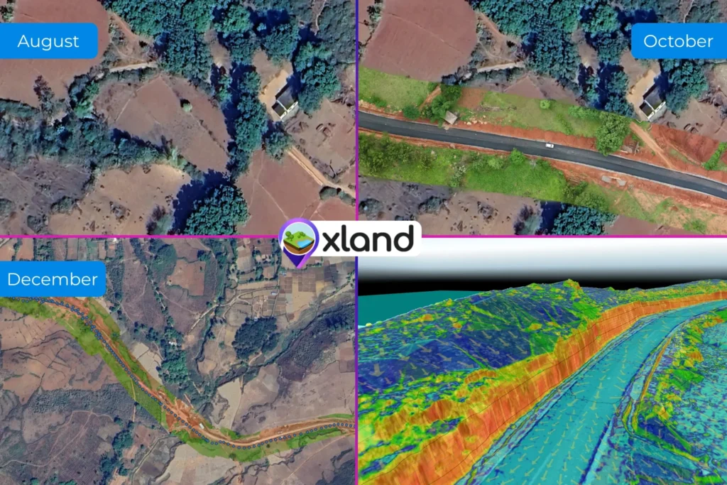
Environmental sustainability is a key consideration in modern industrial setups. GIS facilitates detailed Environmental Impact Assessments by providing real-time spatial data on land use, vegetation cover, and wildlife habitats. Through overlaying maps and analyzing patterns, companies can predict the environmental consequences of their operations and explore alternative solutions to mitigate harm.
For example, GIS can identify regions where construction would disrupt ecosystems minimally, thereby supporting the development of more eco-friendly industrial projects.
3. Optimizing Infrastructure and Logistics
Efficient logistics and infrastructure planning are vital for industrial plant operations. GIS plays a crucial role in analyzing and designing transportation routes, utility networks, and supply chain pathways. It enables the visualization of existing infrastructure and identifies gaps that could hinder operations.
By simulating various scenarios, GIS can help companies choose the most cost-effective and efficient logistics solutions. For instance, a manufacturer can determine the optimal route for transporting raw materials to the plant and finished goods to market, reducing transit time and costs.
4. Community Engagement and Regulatory Compliance
Industrial plant setups often face resistance from local communities due to concerns over environmental and social impacts. GIS tools provide a transparent platform to engage with stakeholders, showcasing how a project aligns with regional development goals and mitigates potential risks. By visually demonstrating compliance with zoning laws, pollution norms, and other regulatory requirements, companies can build trust and gain the necessary approvals more efficiently.
5. Risk Management and Disaster Preparedness
Industrial plants are susceptible to various risks, from natural disasters to technological failures. GIS enables proactive risk management by identifying vulnerabilities and preparing contingency plans. For example, GIS can model potential flood zones and suggest the best locations for constructing protective barriers or identifying safe zones for evacuation.
Moreover, real-time GIS data allows for better disaster response planning, ensuring minimal downtime and safeguarding employees and assets.
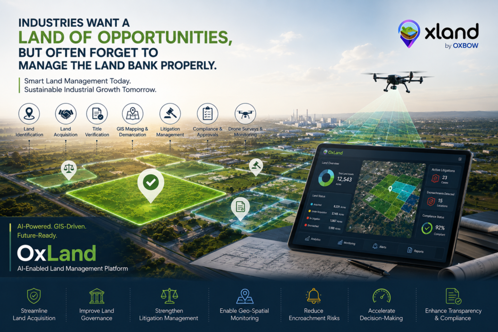
6. Aids in Land Valuation and Cost Estimation
The Record of Rights (ROR) and ownership details, combined with Geographic Information Systems (GIS), play a crucial role in land valuation and cost estimation for industrial plant setups. GIS integrates ROR data with spatial mapping, offering a comprehensive view of land ownership, boundaries, and usage patterns. This enables businesses to assess legal ownership, tenancy, and encumbrances with greater accuracy and efficiency. By overlaying GIS data, organizations can identify land suitability, estimate costs, and visualize factors like accessibility and proximity to resources. This integration ensures precise budgeting, minimizes legal risks, and accelerates strategic planning for seamless plant setup execution.
How Oxbow Intellect Can Help
Oxbow Intellect specializes in integrating advanced GIS technologies into strategic industrial planning. Our expertise ensures precise site selection, efficient infrastructure planning, and robust risk management solutions tailored to your project’s unique requirements. Partnering with us guarantees that your industrial plant setup is not only operationally efficient but also environmentally responsible and compliant with all regulatory standards.